


Sri Lanka – A civilization worth travelling for
Many visitors arrive in Sri Lanka already knowing about its beaches, wildlife, tea country and tropical landscapes.
The intellectual importance of places such as Anuradhapura is less widely understood internationally.
Yet this is precisely what can make a journey here especially rewarding.
A traveller is not simply visiting monuments created long ago.
They are entering the remains of a society that had to answer questions still familiar to us today:
How do we store water?
How do we use limited resources efficiently?
How do we support agriculture through seasonal uncertainty?
How do rural production and cities depend on one another?
How should infrastructure respond to the natural landscape rather than fight against it?
How should infrastructure respond to the natural landscape rather than fight against it?
The answers ancient Sri Lanka developed were not perfect, nor should they be romanticised.
But they were substantial enough to leave reservoirs, canals, agricultural landscapes and monumental cities that can still be studied today.
That is what makes Anuradhapura more than a collection of ancient ruins.
It is the surviving footprint of a planned human landscape.
And Yodha Ela offers one of the clearest ways to understand it.
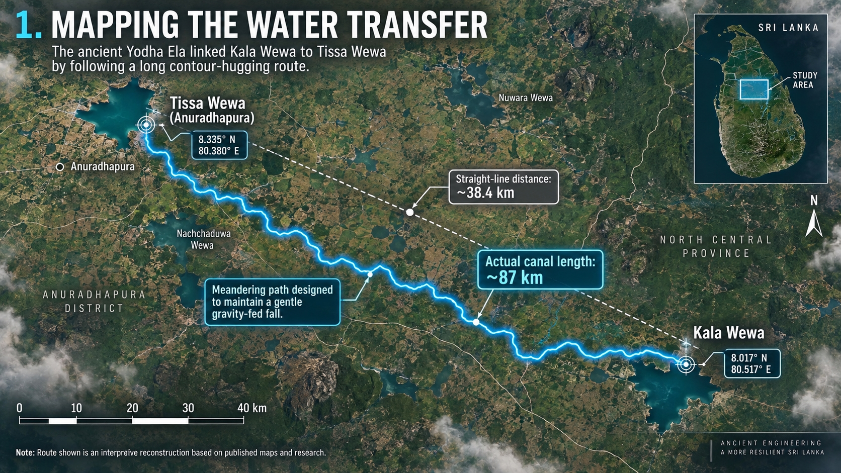
The canal’s greatest achievement may therefore not have been carrying water for 87 kilometres.
It was helping turn water into agriculture, agriculture into economic surplus, and economic surplus into civilization.
For the traveller who understands that connection, Anuradhapura begins to look very different.
You are no longer simply looking at what an ancient civilization built.
You are beginning to understand how it worked.
Water was economic infrastructure
Ancient cities could not survive simply because their rulers knew how to construct impressive buildings.
A great urban and religious centre required food.
Food required agriculture.
Agriculture in Sri Lanka’s dry zone required dependable access to water.
Agricultural surplus, in turn, could support people who were not producing food themselves: monks, craftsmen, builders, administrators, traders and others participating in urban life.
Seen from this perspective, Kala Wewa and Yodha Ela were not merely engineering monuments.
They were economic infrastructure.
UNESCO’s documentation on Anuradhapura makes this relationship unusually clear. The great artificial reservoirs surrounding the city supplied water to the city and monasteries while also irrigating the rice fields that provided its immediate food supply.
Water, agriculture, religion and urban civilization were therefore not separate stories.
They depended upon each other.
The question that remains
Perhaps the most intriguing part of Yodha Ela is not its length.
Nor even its gradient.
It is the question of surveying.
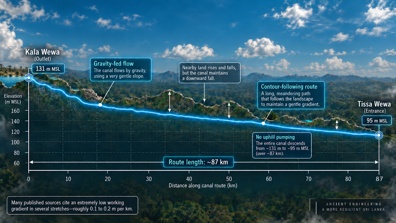
Finding a route that follows subtle changes in elevation across tens of kilometres is difficult even to understand by eye.
Modern researchers can now place the canal against digital contour maps and satellite-derived elevation models.
Ancient engineers did not have those tools.
Exactly how they surveyed every part of the route remains a fascinating subject for historians and engineers.
But we do not need speculation to appreciate what survives.
The reservoirs exist.
Sections of the canal exist.
Its route can be mapped.
Its elevations can be measured.
Its relationship with the surrounding terrain can be analysed using modern scientific tools.
In other words, Yodha Ela does not need mythology to make it impressive.
The measurable evidence is interesting enough.
An ancient version of landscape-scale thinking
It would be misleading to say that the people of ancient Anuradhapura were practising “modern sustainability.”
They did not use that vocabulary.
But several principles visible in their infrastructure are remarkably familiar to modern discussions of sustainable development.
They used gravity rather than continuous mechanical energy to move water.
They stored water in reservoirs rather than depending entirely on seasonal rainfall.
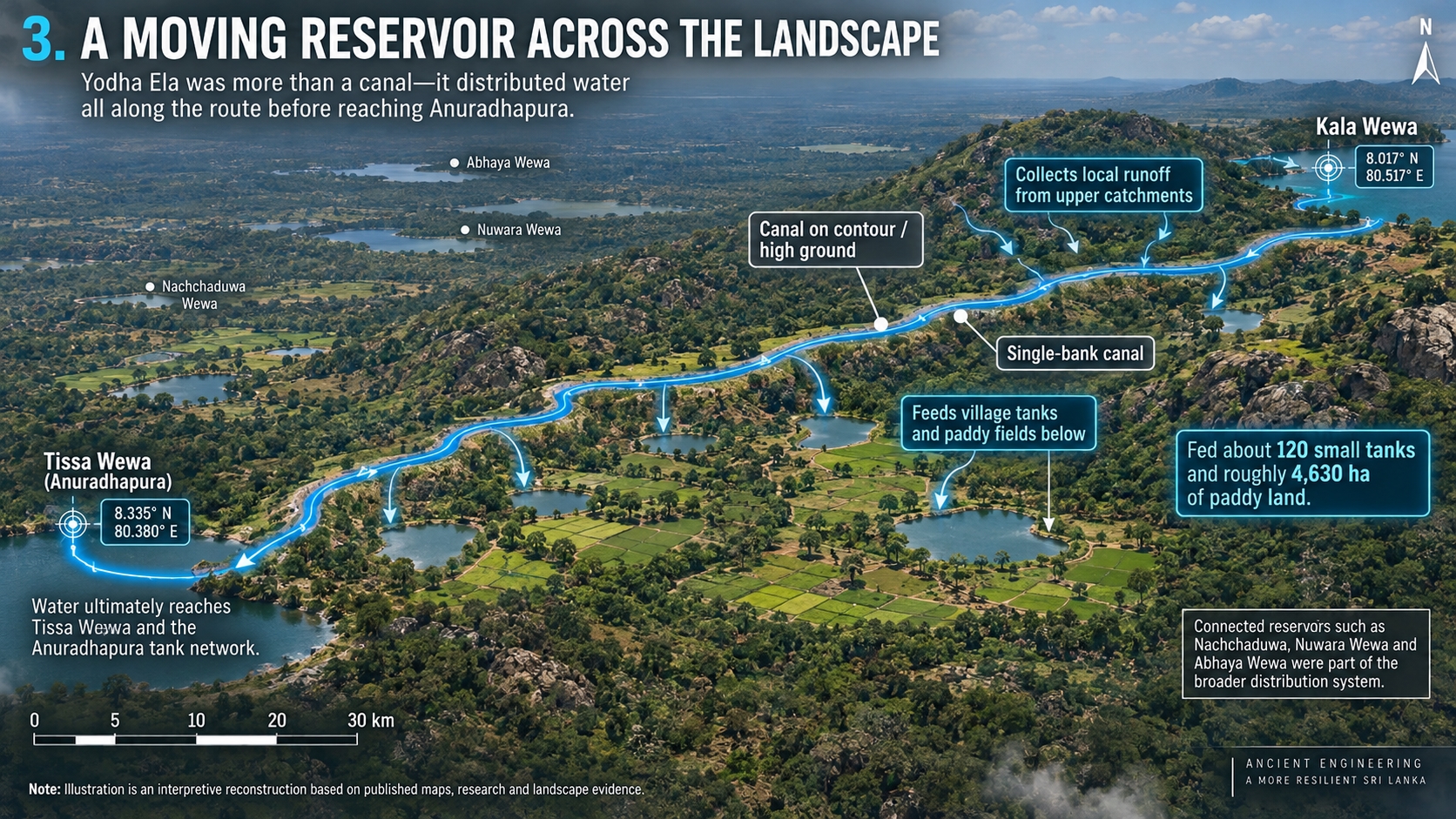
They connected large reservoirs with smaller water systems.
They adapted canals to natural topography.
They distributed water through agricultural landscapes instead of treating water solely as an urban resource.
And the system supported both human settlement and food production over long periods.
Modern research on Yodha Ela specifically highlights its relationship with natural drainage, contour-following design and environmental water management.
The most interesting lesson may therefore be that the ancient engineers were not simply designing individual structures.
They were managing relationships between structures and landscape.